
blah blah blah
Thoreau Falls
Length: 12.1 miles out-and-backDifficulty (click for info): Very Hard
Elevation Gain: 1700 feet (+680 feet on return)
Rating (click for info): 10/10
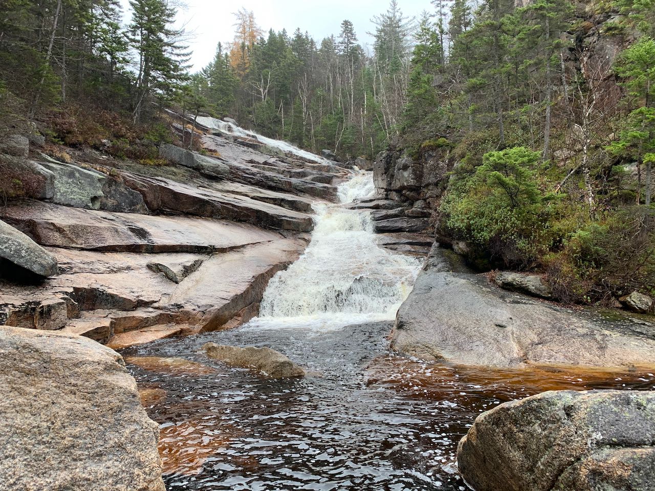
Height: 80'
Source: North Fork of the East Branch of the Pemigewasset River
Driving Directions:
Trailhead and parking area are on Willey House Station Road in Harts Location, NH (falls are in Lincoln). This road leaves Rt. 302 12.2 miles southeast of Rt. 3 and 16.8 miles west and northwest of Rt. 16. Look for the entrance at a state park sign for Ripley Falls on the south side of the road, a mile south of the Willey House and just west of a bridge over Avalanche Brook. Drive 0.3 miles up the road to the lot at the end. If there is no parking here, it is an option to park at the base of the road and walk up. In winter, the road is not plowed and the only parking is at the base. Click here for a Google map.
About the Hike:
Thoreau Falls is one of New Hampshire's most spectacular waterfalls, and it would surely receive more acclaim were it a little more accessible. It's a five-mile slog into the Pemigewasset Wilderness just to reach it, but much of its appeal is because of its wild and remote character. Thoreau is positioned on one of the primary watercourses that forms the headwaters of the Pemigewasset (and Merrimack) River, and it is one of the state's highest volume waterfalls. The asthetics of the falls are absolutely picturesque. It's a long, curvy waterfall that drapes out over expansive ledges, and at the top of the ledges is a lovely view into the heart of the wilderness. The long trip out to the falls is nearly as captivating. As you journey deeper in the wilderness, the environment only seems to become more lush and mystical. The latter part of the hike includes a stretch where the trail follows close beside the North Fork of the East Branch of the Pemigewasset River alongside rapids and cascades over ledges. The trail also passes near Ethan Pond and Shoal Pond, both of which are some of the most pristine wilderness ponds to be found and offer more views of the surrounding mountains. Both are short side trips off the main trail. We can't forget also that right near the beginning, you'll pass close by Ripley Falls, one of New Hampshire's premiere and most famous waterfalls. Most hikers who are making the long trip out to Thoreau have probably already experienced Ripley Falls, but we're including the quick side trip to it on this page just because it's never worth skipping!
From the parking area, begin your hike on the Ethan Pond Trail. The trail nears Avalanche Brook, the source of Ripley Falls, then climbs to and crosses the tracks of the Conway Scenic Railroad, from which there is a slight view up to the looming summit of Mt. Willey. A moderate climb of 0.15 miles over rocky steps leads to the junction with Arethusa-Ripley Falls Trail. For the side trip to Ripley Falls, turn left here. The trail slices across the hillside on a nearly flat course, climbing slightly. In the spring, this section can become very muddy, as many seasonal streams flow across it. After 0.35 miles, the trail drops steeply over roots and rocks to a pile of rocks beside the pool at the base of Ripley Falls. The trail crosses to the other side, but this is as far as you need to go to enjoy the awe-inspiring beauty. In its peak season, torrents of water drape across the angled cliffs to create a majestic sheet of foamy white. The mist of the waterfall usually rises and permeates the air in this secluded little hollow.
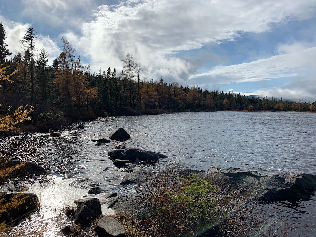
Back at the junction, continue up the Ethan Pond Trail. It makes a steep, steady climb up a very long dirt-and-log staircase, then eventually moderates and traverses easier terrain for a while. A few seasonal streams are crossed. After a mile, pass Kedron Flume Trail on the right. Continue 0.3 miles, and arrive at the southern end of the Willey Range Trail. Take a left at this junction to stay on Ethan Pond Trail. The trail climbs moderately through spruce and birch forest for about a quarter mile before it starts to level off. It then spends 0.6 miles wandering across the broad plateau situated just below the sharp cone of Mt. Willey which divides the Saco River basin from the Pemigewasset River basin. With gnarly spruce thickets on each side, the trail crosses over extensive boggy terrain, where log bridges provide footing over the spongey moss. After crossing over the barely noticeable height of the plateau, the trail begins to descend into the eastern side of the vast Pemigewasset Wilderness. Chains of log bridges continue and alternate with some drier ground. After 0.15 miles, arrive at the junction with the spur to Ethan Pond. Take a right here and follow the path for little under 0.1 miles and cross the inlet stream to the pond on a bridge of stepping stones. This small brook, which flows down from a smaller pond up near the top of the plateau, is one of many streams in the eastern Pemi that, depending on which of them has the most volume, could be considered the infant Pemigewasset/Merrimack River. The trail leads out to a nice area of rocks on the east end of the oval-shaped pond, where there is plenty of room to take a seat and enjoy the scenery of the beautiful dark waters. In the background there is a view of Mt. Bond on the right and Mt. Hancock on the left. The craggy cliffs on the ridge rising up to Mt. Willey on the north side of the pond create a wild contrast with the gentle terrain around the plateau. The spur path continues a bit past the pond up the hill to a shelter.
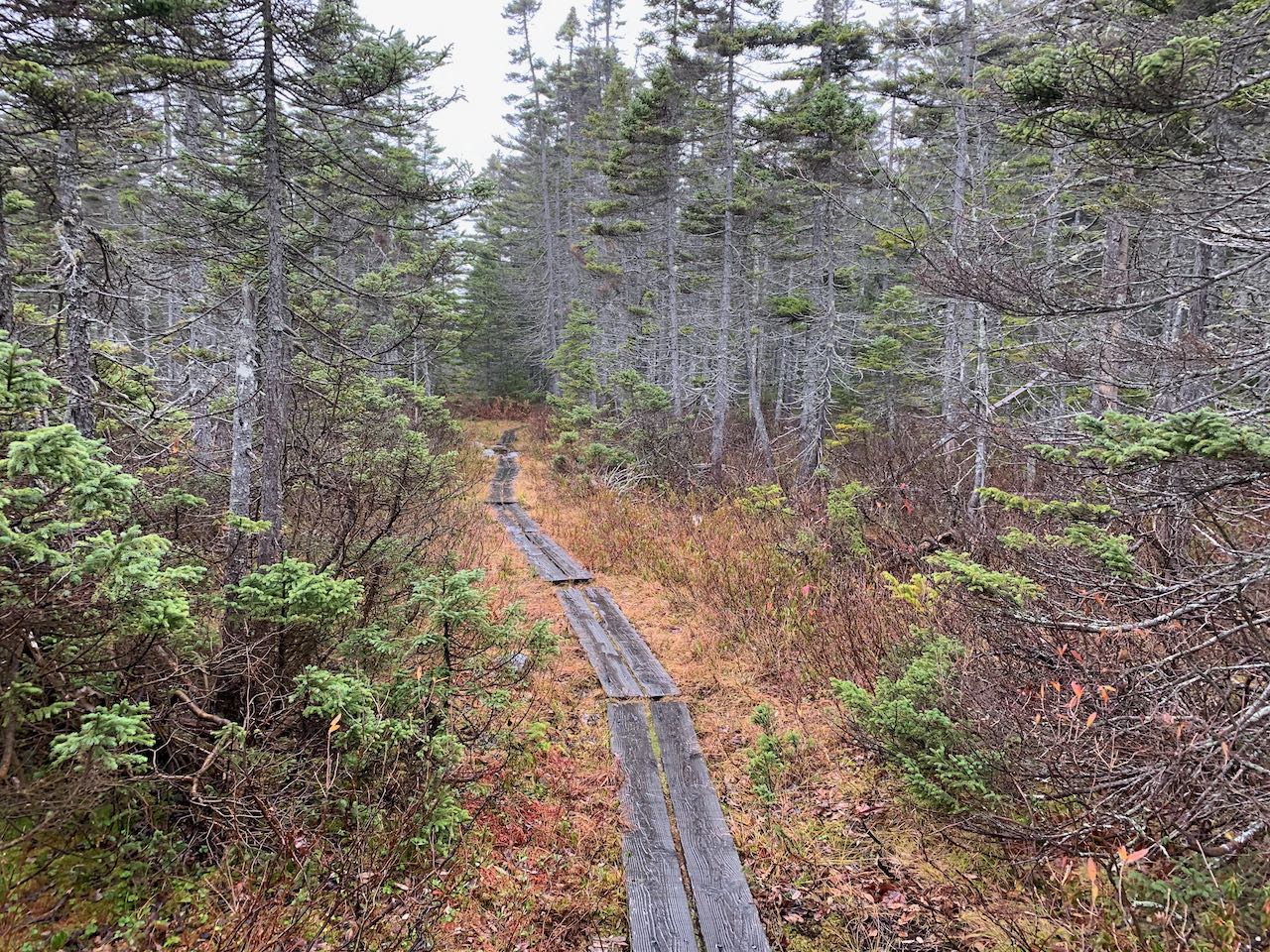
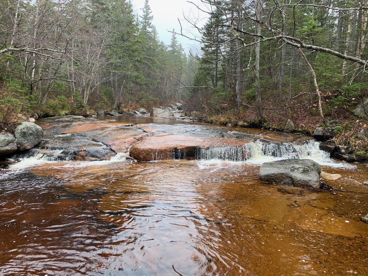
The trail continues its gentle descent past Ethan Pond over more alternately wet and dry ground, with lush vegetation all around. It passes through a few more open wetlands along the way, where stands of larch trees will make for spectacular foliage displays in the fall. After 0.7 miles, the trail makes a right turn onto higher and drier ground to stay between two swamps. Passing over a small rise, the trail comes within sight of the outlet brook of Ethan Pond in a ravine far below, then continues descending. More of the same wet terrain with log bridges follows as you continue deeper into the wilderness. The trail crosses a few little streams, and after a half mile, it starts to approach the river, which is now the offical North Fork of the East Branch of the Pemigewasset River after enough streams have merged together. It stays about 100 feet away from the river for a bit, then the river turns away and the trail continues with little elevation change into more sparse spruce forest. After 0.6 miles, the trail approaches the river once again and this time comes out to a nice viewpoint in a particularly scenic area with colorful ledge slabs. It stays close beside the river for a short distance past short cascades and deep pools, then arrives at a junction with Shoal Pond Trail after 0.15 miles.
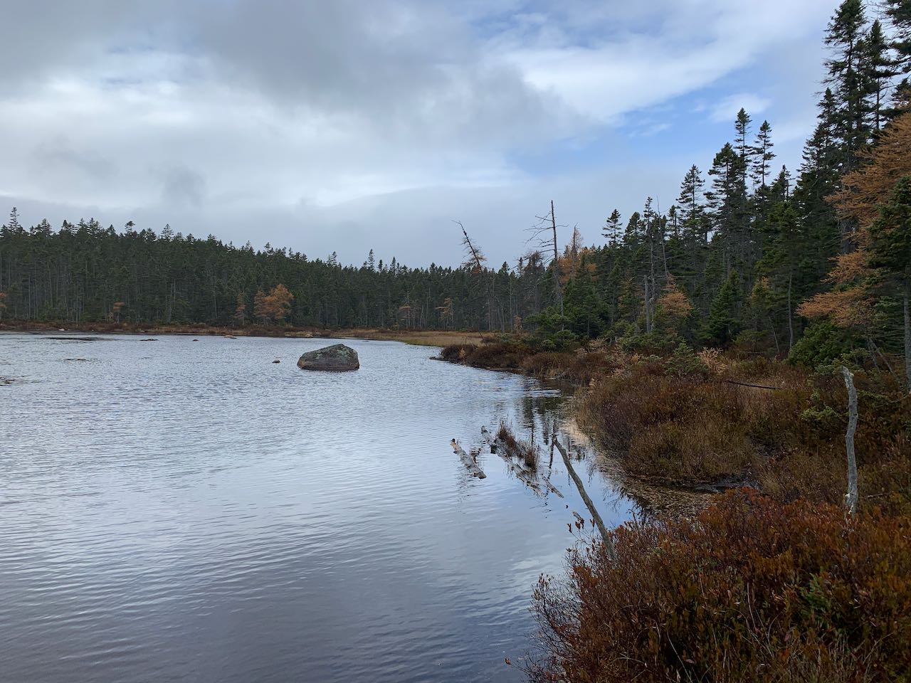
At this point, you can choose to take a side trip to see another gem of the wilderness, Shoal Pond. Turn left onto the much less used Shoal Pond Trail, a very narrow track through the woods, and cross into the Pemigewasset Wilderness. It soon reaches boggy terrain, where the way may be a bit overgrown. Half a mile down the trail, a couple side paths lead out to the water's edge toward the middle of the pond. Walk out to a clear spot through the low bushes and grasses around the shoreline and you'll have a nice clear view over the secluded little pond. Across the peaceful waters, the west side of the pond is rimmed with stately spruces and a few independent larches, while on the east side of the pond, the larches dominate. Looking to the left over the pond, Mt. Carrigain is visible in the distance, and to the right, part of Whitewall Mountain can be seen.
Back on the main trail, continue in proximity to the river for another 0.3 miles, and the trail crosses over to the other side on a wooden bridge, with another pretty view of the river. After an easy walk of 0.2 miles on the north side of the river, reach a junction with Thoreau Falls Trail. Take a left and walk 0.1 miles, passing the boundary of the Pemigewasset Wilderness, to the top of Thoreau Falls. The trail continues on the other side of the river, but you don't need to cross. The spacious ledges atop the falls provide the best view. The combination of a backdrop of mountain peaks and foamy whitewater crashing down ledges is an amazing scene. Use caution around the top of the falls; although there is no precipitous dropoff, it can be slippery from the mist. The torrent of the river curls around on the left side of the ledges as it careens down the 80-foot waterslide. It's harder to get a view of the falls from the bottom, but it is well worth the effort. You'll be able to find beaten paths leading downstream from just before where the trail comes out to the top of the falls. There are multiple routes and some stay closer to the river than others. When you can look back through the trees and see the whole waterfall, look for one of the paths that climbs down to the river. Be careful scrambling down the embankment, as it may be loose footing. On the side of the pool beneath the falls is an area where large boulders have settled. From here you have a clear view straight on at the bottom of the falls, which is steeper than the top. You can see the beautiful fanned-out shape of the lower drop, which starts narrow and widens out as it slides into the pool. A few more cascades continue downstream of you as the water continues on its journey through the wilderness.
Printable directions page